Sophie kaplan-bucciarelli
MLA Landscape Architecture
Watershed Amendments: New Pervious Grounds
In Providence, RI, much of the downtown area is built over a vast historic tidal estuary. Though we no longer see the salt marshes, wooded bluffs, or meadows that once characterized this landscape, we recognize their absence in contemporary crises of urban heat, flooding, polluted soils and stormwater runoff, and habitat loss. These conditions are particularly acute along the city’s industrialized river corridors, where vacant lots and parking areas sit idle, their history paved over and potential constrained by limited imagination and resources.
These lots—already experiments in fill and land building after centuries of disturbance—can be reconsidered as test plots for urban environmental and community engagement. By working intentionally within their current condition, these landscapes can be ‘amended’ to invite life to emerge from the pavement.
Amidst the flat and inhospitable conditions of the postindustrial parking lot, brush and yard debris can shape new gathering spaces for people and support living urban soils after de-paving. Compost and urban landscape ‘waste’ are abundant and underconsidered environmental resources in the city. Diverting this material away from the landfill and back to the land creates the opportunity for new relationships across green infrastructure, biodiversity, waste management, and community arts and education.
Layered into pavement where marsh once thrived, Watershed Amendments positions landscape ‘waste’ as the basis for experimental ecologies and participatory urban spaces that recall historic ecological richness, reconnect moments of the watershed, and invite experimentation and continual learning with the city.
Image
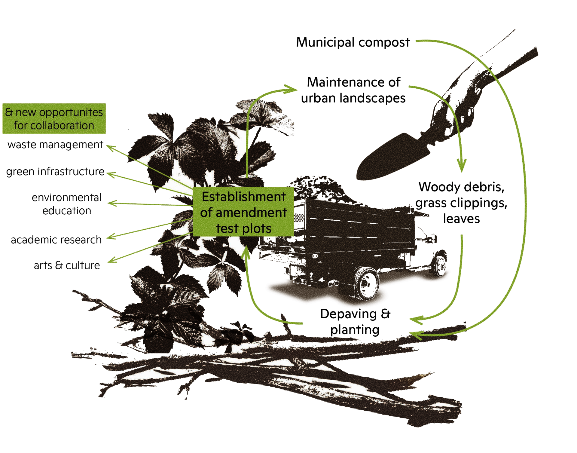
System diagram showing how landscape 'waste' could be diverted away from the landfill and back to the land, producing the conditions for experimental landscapes and local collaboration networks in the city.
Image
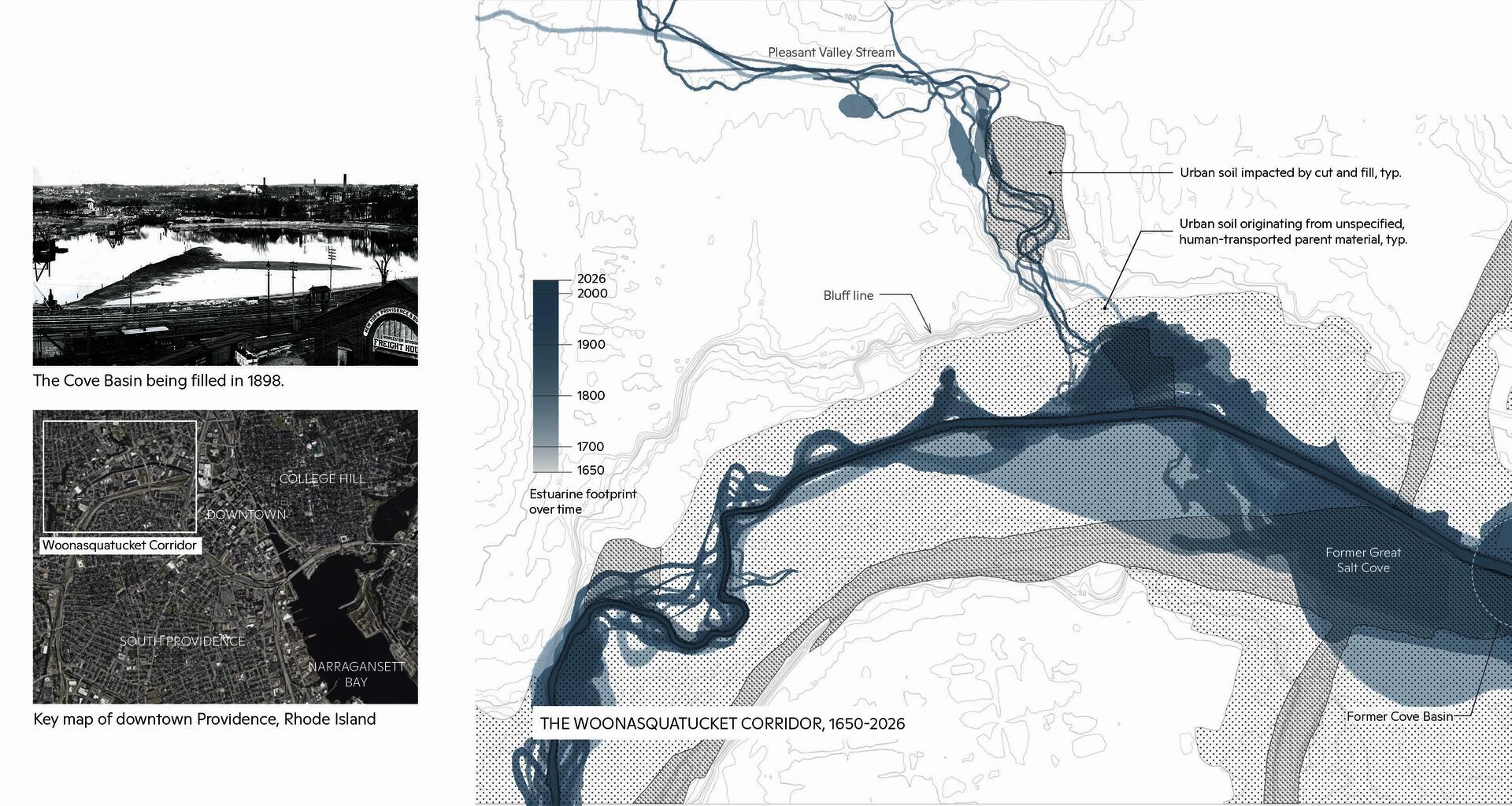
The majority of downtown Providence was built over a vast estuarine ecosystem that once stretched across the low land at the northern tip of the Narragansett Bay. This map shows the progression of land filling and engineering that buried the salt marsh to support industrial manufacturing in the 1800s.
Today over 65% of the city is impervious, meaning that groundwater recharge is significantly impaired and the city's aging stormwater system is put under increasing stress with increasing climate events. The majority of urban soils that remain un-paved are functionally impervious due to compaction and disturbance. Interventions to mitigate paved and compacted soils are a critical strategy for urban resilience.
Image
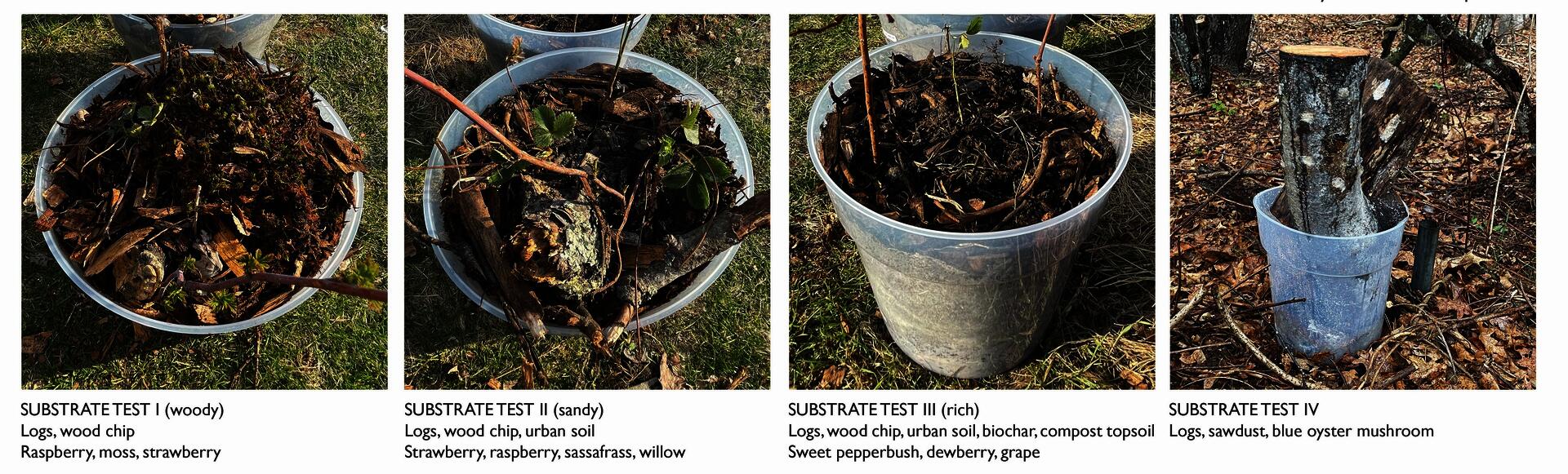
These planters tested the establishment of native species in substrates with differing proportions of landscape 'waste' and urban soils. Scaled up to site and layered into de-paved areas, this combination of regenerative and widely-available material could become the basis for climate-adapted urban ecological research, soil and stormwater testing, and citizen science projects.
Image
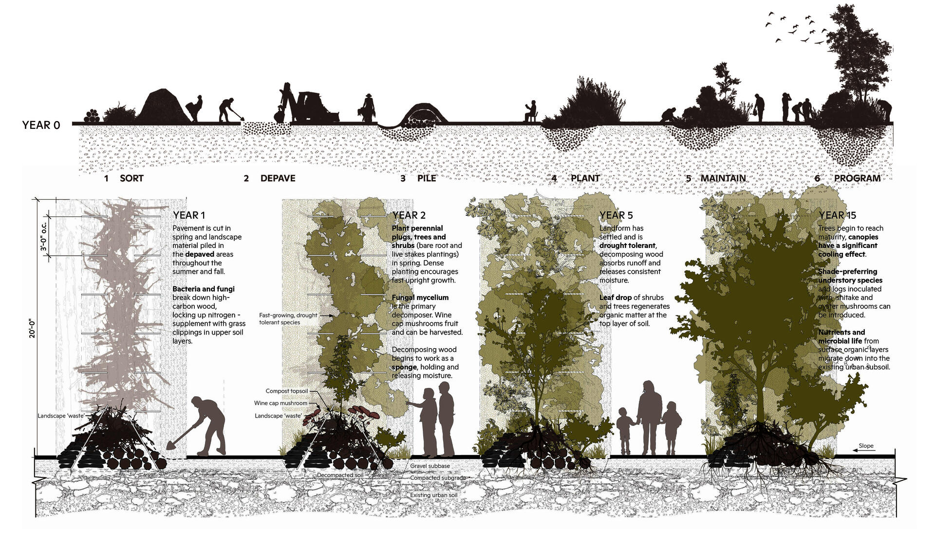
Progression from landscape 'waste' collection to establishment of test plot landscapes, wherein programming isn't intended to be an end point, but rather to weave through the other steps to engage people in collecting and sorting material, depaving, and planting the landforms. Built from woody debris and layers of other organic 'waste' such as grass clippings, leaves, and compost, the berms establish a nutrient-rich habitat and expand the potential root zone amidst the surrounding pavement.
These structures, densely planted with fast-growing and drought-tolerant species with native habitat value, accelerate ecological succession to provide shelter and shade for human and more-than-human species within a relatively quick time frame.
Image
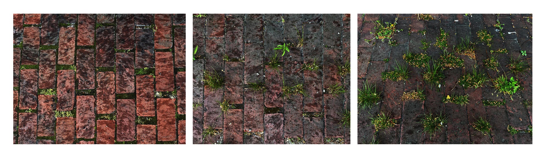
Making cuts in impervious surfaces allows for accumulation of sediment, infiltration of water, and subsequent plant life to emerge. These brick pavers exemplify these dynamics on a small scale, but they hold true at the site scale as well.
Video file
Potential configurations of pavement cuts for a vacant lot north of the Woonasquatucket River. Different arrangements respond to conditions of slope and aspect while also shaping corridors and spaces for people. The design considers truck access and material delivery by leaving some paved areas for storage and sorting of landscape 'waste' prior to its installation in the soil.
Image
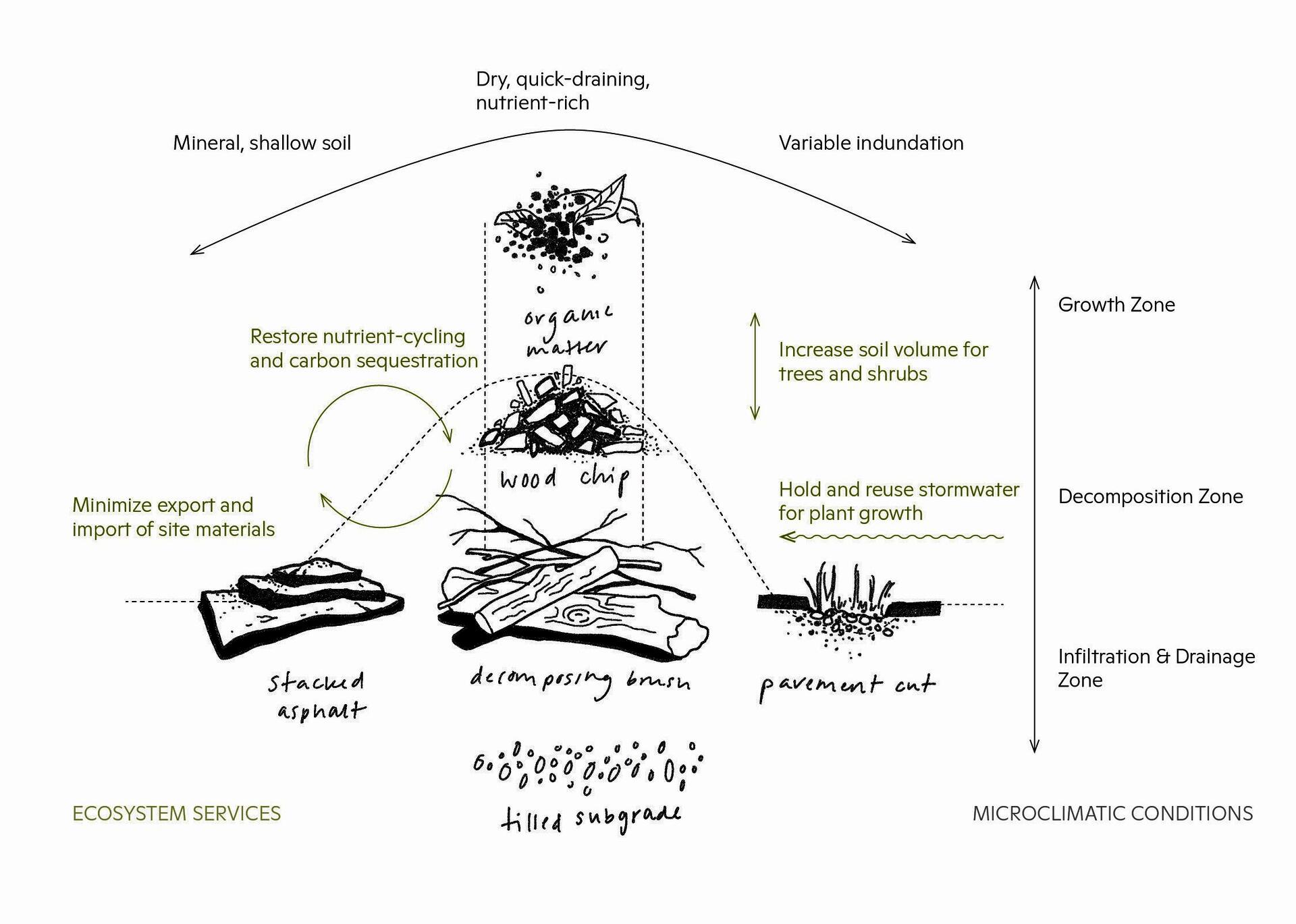
Landforms create a series of microclimatic niches that situate themselves both according to the constructed substrate and to their position along the slope of the berm. In the context of a parking lot, full sun, variable water, and frequent disturbance are also influential factors on the conditions for plant growth.
Image
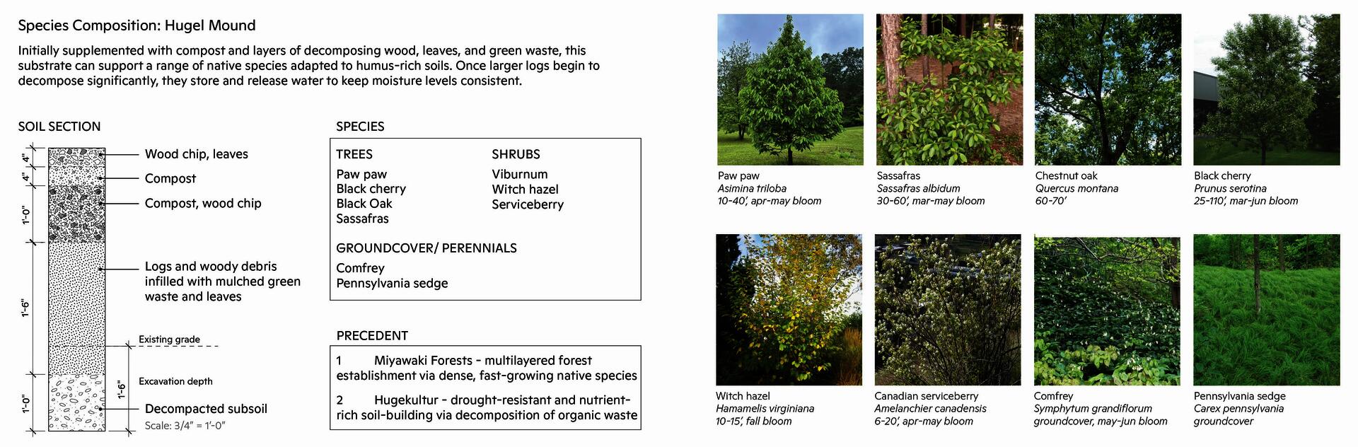
This plant palette comes together around species selected for their hardiness, habitat value, seasonal interest, and suitability for nutrient-rich substrates. They must be relatively quick-growing in order to out-compete non-endemic competitive species, drought-tolerant, and able to navigate the uneven ground of the berm as it settles. These species will quickly establish a multilayered canopy, opening up new planting possibilities in the understory as shade develops.
Image

Rhode Island School of Design
20 Washington Place
Providence, RI 02913–2784
United States of America
+1 401 454 6100
+1 800 364 RISD
QUICK LINKS
risd.edu
Graduate Studies
Image
Rhode Island School of Design
20 Washington Place
Providence, RI 02913–2784
United States of America
+1 401 454 6100
+1 800 364 RISD